Converting palm oil companies from forest destroyers into forest protectors
mongabay.com: Jeremy Hance and Rhett A. Butler: January 02, 2011
In efforts to save the world’s remaining rainforests great hopes have been pinned on “degraded lands” — deforested lands that are presently sitting idle in tropical countries. Optimists say shifting agriculture to such lands will help humanity produce enough food to meet growing demand without sacrificing forests and biodiversity and exacerbating social conflict. But to date, degraded lands remain an enigma, especially in Indonesia, where deforestation continues at a rapid pace. Degraded lands are often misclassified by various Indonesian ministries—land in a far-off province may be listed as “wasteland” by Jakarta, but in reality is blanked by verdant forest that sequesters carbon, houses wildlife, and affords communities with food, water, and other essentials. Granting logging and plantation concessions on these lands can result in conflict and environmental degradation.
Therefore key to unlocking the potential of non-forest land, and thus setting Indonesia on a low carbon development pathway, is determining where degraded lands actually exist. But the process goes beyond mere land cover mapping. Decision-makers must have the full picture of the land: its ownership and use, its state of degradation and suitability for agriculture, and an understanding of the actions needed to restore it to productivity.
Under the billion dollar Indonesia-Norway partnership to reduce deforestation, some money has been allocated for degraded lands mapping. But even before the pact was signed this past May, the World Resources Institute (WRI) had launched a project to identify degraded lands in the country. Working with local partners, WRI is focusing on ways to address one of Indonesia’s most important drivers of deforestation: palm oil production.
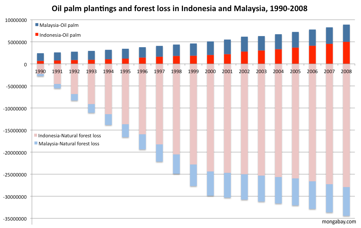 Over the past twenty years, palm oil has emerged as a economic juggernaut in Indonesia and Malaysia. With its high yield, oil palm is an astoundingly profitable crop and accordingly, plantations have spread across Sumatra, Borneo, New Guinea, and other islands, taking a heavy toll on forests. By some estimates, more than half of oil palm expansion since 1990 occurred at the expense of forests. In the absence of action, the trend is expected to continue, driven by rising demand for vegetable oil.
WRI is interested in ensuring that future growth doesn’t lay waste to remaining forests. Therefore its mapping project aims to identify sites for “land swaps” whereby concessions on forest land could be shifted to deforested grasslands. The initiative also provides guidelines to plantation companies for obtaining the free, prior, and informed consent of communities living near the degraded area and achieving Roundtable on Sustainable Palm Oil (RSPO) certification.
In a December 2010 interview with mongabay.com, WRI’s Craig Hanson and Moray McLeish discussed how the initiative could turn palm oil companies from drivers of deforestation into forest protectors.
An interview with Craig Hanson and Moray McLeish
What are your backgrounds?
Craig Hanson is the Director of the People & Ecosystems Program at the World Resources Institute. Prior to joining WRI, Craig was a project manager at an international management consulting firm.
Moray McLeish is the manager of Project POTICO at the World Resources Institute. POTICO (Palm oil, Timber, Carbon Offsets) convenes and leads a number of partners to implement land swaps that divert planned oil palm plantations on degraded lands and bring the forests that are slated for conversion into sustainable management. Prior to joining WRI, Moray worked on forest conservation in Indonesia with the IFC and The Nature Conservancy.
DEGRADED LANDS
What is the definition of degraded land?
“Degraded land” refers to areas that were cleared of their natural vegetation cover, now contain low levels of biodiversity and low stocks of carbon, and are not used for productive agriculture or human habitation. Alang-alang grasslands (Imperata cylindrica) are an example of such degraded lands in Indonesia.
Note that what we are talking about is not strictly degraded “land”. The areas do not necessarily have poor soil quality. Rather, what we are referring to is degraded “land cover.” The area’s ecosystem is degraded relative to what was there before—in the case of Indonesia, tropical rain forest.
Definitions fit within a context. Since the context in which we are working—breaking the link between oil palm development and greenhouse gas emissions—involves policies and actions designed to reduce greenhouse gas emissions, the definition of “degraded land” given above is taken from a “forest carbon” perspective.
Definitions are important. The recent interaction between Greenpeace and the Government of Indonesia over “loose definitions” of land conditions, what lands may or may not be developed into plantations, and related matters highlights this importance.
Could secondary forests, which may have biodiversity or climate potential, be considered degraded land?
Many secondary forests (or degraded forests) certainly do have biodiversity and climate (carbon storage) potential. It is critical that these forests are identified and prioritized for rehabilitation. But other secondary forests may be so badly cleared that restoration is not economically feasible or practically realistic. This is why clear and pragmatic definitions of “degraded” are so important—to help stakeholders plan what to do with what land and where to focus efforts to maximize benefits to local people, biodiversity, the economy, and the climate.
FOOD OR FOREST?
Should degraded lands be restored to forests or converted to agriculture?
Decisions about degraded land use should be determined by individual countries in careful consultation with the communities living near them. The decisions should respect existing land rights, including customary use rights. Factors to consider when making choices about different land uses include: To what degree is agricultural expansion a direct driver of deforestation? What is the level of food security in the region or country? What is the relative ease, biophysically and economically, of restoring the land to either forest or farms? Is the area of degraded land in question adjacent to a waterway where erosion is a problem? What is the country’s forest conservation and REDD+ aspirations? In short, these considerations are about what ecosystem services are desired from these landscapes.
How these and other questions are answered should guide decisions regarding the optimal use of a particular degraded area. For example, if agricultural expansion into natural forests is the number one driver of deforestation in country X and the country has committed to curbing deforestation, then utilizing already cleared and degraded areas as a “pressure-relief valve” for agricultural expansion may make sense. However, if agricultural expansion into forests is not a driver of deforestation in country X but another issue, say erosion, is a big concern, then restoring degraded areas back to their natural ecosystem (e.g., forests) may make the most sense.
And finally, we shouldn’t forget that it isn’t necessarily “either/or”. Some tracts could be restored to agro-forestry landscapes.
Since degraded land at one time was usually forest, shouldn’t some degraded land be reforested for biodiversity and climate?
Yes, certainly. This relates to our earlier point of needing to manage land to provide a bundle of ecosystem services—freshwater, erosion control, climate regulation, food, recreation and cultural values, etc. As a result, some degraded areas should be restored back into forests or whatever natural ecosystem the landscape was before it was degraded, especially where these areas provide valuable ecosystem services such as freshwater.
Potentially how much degraded land worldwide could be restored to forests?
A recent analysis by the World Resources Institute (WRI) and partners suggests that there are more than one billion degraded hectares globally—an area larger than Brazil—that offer forest landscape restoration opportunities. These lands could be restored to their native forest state, creating habitat for wildlife, reducing erosion, ensuring clean water supplies, and combating climate change by absorbing carbon dioxide, or restored into mosaic, agro-forest ecosystems.
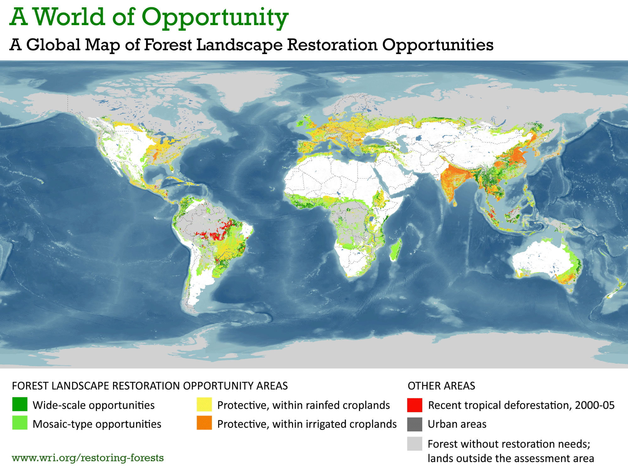 Some of these lands could be cultivated, as well. But exactly how much could and should be turned into cultivation requires a more detailed country-by-country analysis that includes asking “cultivation for what?” We have not conducted that assessment. This should be a participatory process. Furthermore, one should note that WRI’s analysis only looked at degraded forests; we did not look at degraded grasslands, wetlands, or other ecosystems.
How does one identify degraded lands that could be amenable for agriculture, such as palm oil?
While the specifics will differ by crop, by region, etc., most methods would need to screen for biophysical suitability, economic viability, social acceptability, and legal availability of the land.
Along with partners, WRI has developed a methodology for identifying degraded lands, determining which of these are economically viable and socially acceptable for sustainable oil palm, and assessing their legal availability for plantation development. Figure 1 summarizes the key screens used in this methodology:
* Environmental. The area is degraded from a forest carbon perspective (e.g., <40 tons of carbon per hectare). Developing the area will not result in significant greenhouse gas emissions or reduce critical environmental “high conservation values” including biodiversity preservation and clean water supply;
* Economic. The area is biophysically capable of profitable oil palm production in terms of climate, topography, and soil properties. Highest priority areas meet minimum plantation size and proximity to infrastructure requirements;
* Social. Local people are likely to benefit from plantation establishment and agree to participate in a free prior and informed consent process; and
* Legal. Legal land status allows for conversion to oil palm plantation and expansion does not conflict with existing concessions or other rights, including traditional rights of indigenous communities. 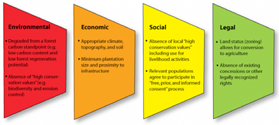
Screening criteria for identifying acceptable areas for sustainable oil palm expansion (Source: WRI)
One should note that some areas that are acceptable according to environmental, economic, and social criteria may be currently unavailable to planters for legal reasons. For example, some of these degraded areas may not be zoned for agricultural activities. This does not mean, however, that the area should necessarily be removed from consideration, since zoning can be changed.
CHALLENGES CONFRONTING DEGRADED LAND
Often logging a forest is used to pay the ‘down payment’ on starting a plantation. Given this, how would new plantations on degraded land be financed?
This may be true in some cases, particularly when stands of commercial timber-rich forest are granted for palm oil. But times may be changing. In collaboration with the Prince’s Rainforests Project and agricultural economist Thomas Fairhurst, we recently interviewed a number palm oil companies in Indonesia about the value to them of expanding into land with tree cover vs. expanding into areas without trees. Many stated they would rather expand onto non-forested land due to the set-up costs and the lengthy bureaucratic processes of getting a permit in forested areas. None of the companies interviewed cited financing—and thus the need for a timber cut to generate cash—as a factor restricting their expansion. Rather, they emphasized the importance of improved spatial planning as the main requirement to reach oil palm development targets as well as forest conservation goals in Indonesia.
In some places such as Indonesia, degraded land has been claimed by small-scale farmers or local communities. How should landownership be determined in such cases?
In all cases, genuine land use and ownership claims must be respected, including the claims of indigenous peoples. In many cases, such claims are not clearly documented, are overlapping, or are conflicting. Our close partner, Sekala, has shown community mapping to be an effective and conflict-reducing way of agreeing and documenting land ownership and use claims – both within a community, and between a community and government or land-using industry.
If communities are to be compensated for providing degraded land to companies, who will pay them?
Of primary importance is ensuring a fair decision making process. The approach of Free, Prior and Informed Consent (FPIC) has been designed to help ensure that communities are not forced into relinquishing land against their will, and that they are appropriately compensated for any land based values or use rights they do choose to relinquish.
LAND SWAPS
How would land swaps work?
One approach for reducing deforestation and peatland degradation in Indonesia that WRI has been working on is to divert planned oil palm plantations away from natural forests and toward degraded lands instead. We sometimes refer to this as a “land swap”. Under a swap, a company that has a permit to clear a tract of natural forest and convert it into an oil palm plantation does not “exercise” that permit but rather develops the plantation on a roughly equivalent-sized tract of degraded land, such as an alang-alang grassland (Imperata cylindrica). Under our model, plantation development in the degraded area follows the procedures of the RSPO (Roundtable on Sustainable Palm Oil), including obtaining the free, prior, and informed consent of communities living near the degraded area. Likewise, a sustainable forest management or conservation plan is put in place for the forest previously slated for conversion. Ecosystem restoration concessions (ERCs) are one mechanism for pursuing the latter. Under an ERC, the government grants the permit holder long term rights to sell ecosystem services produced by the land in return for the obligation to manage the land for ecosystem conservation or restoration with only limited extraction.
Land swaps are part of a broader strategy of utilizing degraded land for plantation development as a means of relieving agricultural pressure on natural forests. In essence, land swaps are an approach for undoing the mistakes of the past—that is, permits or concessions that were allocated on natural forests or peat lands. But only allocating oil palm plantation permits on degraded lands going forward—a strategy supported by Indonesia’s president—would prevent mistakes in the future.
In short, degraded land utilization could allow a country to have its palm oil and its forests, too.
You have written that for degraded land to be used for agriculture it should be “physically suitable, economically viable, legally available, and socially acceptable to nearby communities”. How much land do you think actually fits all of these requirements?
Based on field surveys in just one portion of Borneo, we believe that there is a lot of such land, enough to help relieve some of the pressure agriculture has on natural forests. But “how much degraded land is there?” is less important than “where are these areas?” Answering the former is helpful for headlines; answering the latter is required for land-use decisions. Our methodology is aimed at figuring the latter out. The important thing now is to apply this methodology at national, provincial and district levels, developing maps of where environmentally sustainable agricultural expansion could potentially occur.